

30-Day Rain and Dry Days
- Home
- »
- Search
- »
- Africa
- »
- Continental Africa
- »
Data Sets
Pentadal Period
Continental Africa
Loading subregion products...
Available Tools
The Early Warning eXplorer (EWX) software is an interactive web-based mapping tool that allows users to visualize continental-scale rainfall estimate (RFE), land surface temperature (LST) and normalized difference vegetation index (NDVI) data and anomalies at varied time steps and review time series analyses.
The Early Warning eXplorer (EWX) Lite software is an interactive web-based mapping tool that allows users to visualize time series of rainfall, NDVI, evapotranspiration, land surface temperature and snow water volume, where applicable. The EWX Lite allows users to access the same time series database that drives the standard EWX without having to load raster imagery which can inhibit performance in areas with poor internet connectivity.
Product Documentation
|
(updated April 28, 2021) |
|
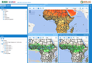
Currently, we produce 30-day rain/dry day products and anomalies for Africa and standard products only for other FEWS NET regions.
For products only, the graphic contains 4 images and corresponds to the last date of a pentadal* period. The upper left image (Number of Rain Days) is the number of days, during the last 30 days, in which at least 1 mm of rain fell; that is, a 'rain day' is defined as a day in which the rainfall amount was greater than or equal to 1 mm. The upper right image (Maximum Consecutive Dry Days) is the maximum number of consecutive dry days in the past 30 days that is, the length of the longest dry spell in the past 30 days, where a 'dry day' was defined as a day in which the rainfall amount was less than 1 mm. The lower left image (Total Accumulated Rainfall) is the total accumulated rainfall amount over the past 30 days. The lower right image (Number of Days Since Rain) is the number of days since a 'rain day'; that is, the number of days since the last 1 mm (or more) of rain was recorded for a day. The input data of a 30-day cycle is the daily preliminary CHIRPS available on a pentadal basis. For products with anomalies (Africa), the same methodology described above is used to generate the image data for rain/dry days, but the graphics produced are four separate sets that consist of a data image (left) and its anomaly (right). The anomaly is the difference between the current day’s image and the average for that day from 2001 – 2015. *pentadal A pentad is a group of 5. We use pentadal to define a group of calendar days - generally 5 days. However, because we confine the calendar year to 72 pentads, and each month to 6 pentads, there are not always 5 days in a pentad. The first 5 pentads of each month have 5 days. The last pentad, or 6th pentad, of each month can have as few as 3 days (for example, Feb with 28 days in non-leap years) and as many as 6 days (Jan, Mar, May, Jul, Aug, Oct, Dec, with 31 days). Because of a one-day lag in data reception and processing, products are updated on the 2nd, 7th, 12th, 17th, 22nd, and 27th of each month. |
Related FEWS NET Services
The Famine Early Warning Systems Network (FEWS NET) is a leading provider of early warning and analysis on acute food insecurity around the world. Explore our other services at the following:
