

GeoTools Overview
- Home
- »
- Software Tools
- »
GeoTools
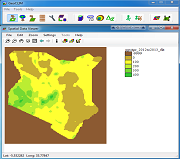
GeoClim
- Analyze large quantities of climate data in raster format.
- Create visual representations of climate-data summaries.
- Calculate seasonal anomalies.
- Blend climate station values with satellite data to create improved datasets.
- Calculate seasonal trends.
- Facilitate drought analysis.
- Compare groups of years within a time series.
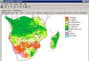
GeoWRSI
The GeoWRSI is a geospatial, stand-alone implementation of the Water Requirements Satisfaction Index (GeoWRSI), as implemented by the U.S. Geological Survey (USGS) for the Famine Early Warning Systems Network (FEWS NET) activity. The program runs a crop-specific water balance model for a user-selected crop in a user-specified region in the world, using raster data inputs. The program produces a range of outputs which can either be used qualitatively to help assess and monitor crop conditions during the crop growing season or regressed with yields to produce yield estimation models and yield estimates. In addition, the program has several tools for validation, enhancement and analysis of both input and output datasets. Other tools are available to post-process the water balance outputs so that they can be used for yield estimation.
Technically, the Water Requirements Satisfaction Index (WRSI) is the ratio of seasonal actual crop evapotranspiration (AETc) to the seasonal crop water requirement, which is the same as the potential crop evapotranspiration (PETc). Originally developed by the Food and Agriculture Organization (FAO), the WRSI has been adapted and extended by USGS in a geospatial application to support FEWS NET monitoring requirements. Yield reduction estimates based on WRSI contribute to food security preparedness and planning. As a monitoring tool, the crop performance indicator can be assessed at the end of every 10-day period during the growing season. As an early warning tool, end- of-season crop performance can be estimated using long-term average meteorological data.
QGIS GeoTools
QGIS3 GeoTools Data Archives
- CHIRPS_2.0_PENTAD_AFRICA_QGIS3_Plugin (794MB)
- CHIRPS_PPT_GLOBAL_DEKADAL_QGIS3_Plugin (2.6GB)
- CHIRPS_PPT_GLOBAL_MONTHLY_QGIS3_Plugin (1.2GB)
- GDASUSGS_PET_GLOBAL_DEKADAL_QGIS3_Plugin (14MB)
- GHORN_TEMP_AVG_QGIS3_Plugin (80MB)
- GHORN_TEMP_MAX_QGIS3_Plugin (81MB)
- GHORN_TEMP_MIN_QGIS3_Plugin (82MB)
- HOBBINS_ET_DEKADAL_QGIS3_Plugin (18MB)
